
How to Search Marion County Property Records
Start with the Marion County Assessor when you need to pin down a parcel. The public search there takes several routes. You can use an owner name, parcel address, account number, district, map and parcel, legal description, property type, or deed book and page. The Sheriff's Tax Office runs its own inquiry. It searches by taxpayer, account, year or ticket, and district-map-parcel-subparcel. Plug the resulting parcel number into the WV Property Viewer to see its map position. Then carry the owner name or deed reference over to the County Clerk's land-record system.
Four kinds of information stay distinct on this path. The assessor shows a tax-roll owner, and that field can lag a recent recording. A tax payment proves nothing about title. A GIS line is not a survey. Online property records can miss an older deed. They can also come back thin. In that case, go to the counter of the office that keeps the record. You can also request an existing copy from its custodian.
- Enter the street address or owner name in the Marion County Assessor search and copy the account and map/parcel values.
- Open the parcel card and note the exact legal description and deed book/page reference.
- Use the Clerk’s land-record categories to ask for the deed, lien, release, or plat tied to that reference.
- Check the Sheriff tax inquiry and WV Property Viewer with the same parcel identifiers.
- Request older or certified material from the office that holds it, and confirm any copy charge directly.
Marion County Property Records Offices
Different offices hold different pieces of the record. Land records, tax assessments, tax collection, and parcel mapping each have their own custodian. Fairmont serves as the county seat. But an office name or a mailing address does not make one source a substitute for another. The Assessor card bridges an address to an account and a deed reference. The Clerk records the land instrument. The Sheriff keeps the tax-account details.
Marion County Clerk
219 Adams Street, P.O. Box 1267
Fairmont, WV 26555
304-367-5445
Marion County Sheriff’s Tax Office
Tax collection and account inquiry
Marion County, West Virginia
304-367-5310
Marion County Assessor Search Fields
The county Assessor allows any mix of search criteria. For an owner-name lookup, type LAST NAME FIRST NAME with no comma. Address and owner name are both optional. So are the account, district, map/parcel, property type, legal-description, and deed-reference fields.
Open the Marion County Assessor search to see the live form. It gathers every field group in one place. The portal does not spell out exact matching rules for each field.
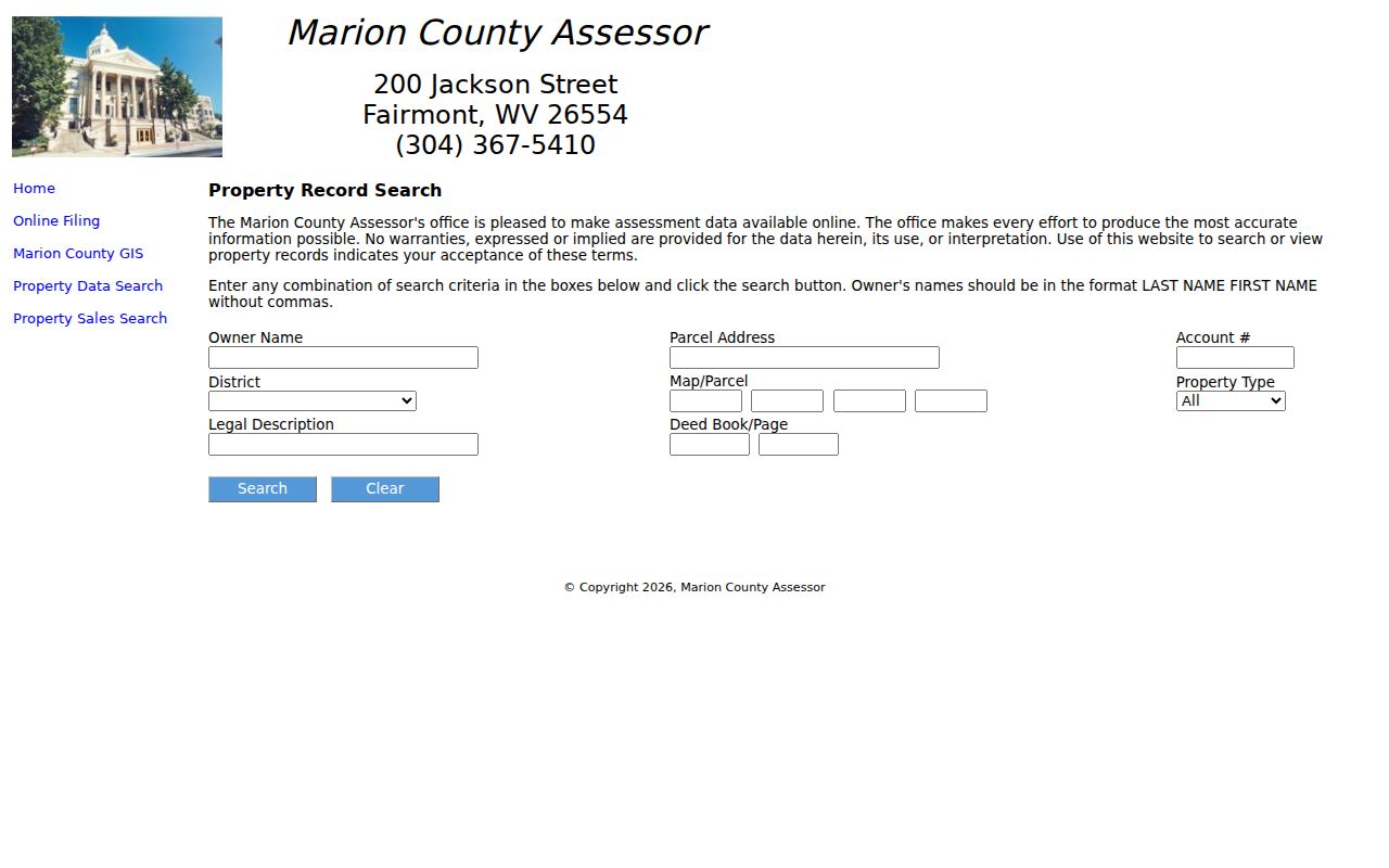
The Assessor's form earns its keep when only part of an address survives, or when all you hold is a stale deed reference. Keep in mind that a blank result does not mean the record is missing.
Marion County Owner-Name Format
Enter the surname first. Then comes the given name. The Assessor asks for no punctuation between the two. Only after you have tried the name exactly as a deed or tax bill spells it should you experiment with initials or a middle name. Handwritten indexes complicate matters further. Estates, trusts, companies, and joint grantees all shift how a name appears, so one shared surname can never link two records on its own. Before you treat two entries as one property trail, compare the account number, parcel number, and legal description. Then check the spouse or co-grantee and the deed book and page.
Marion County Deed Index Access
Marion County's land-record directory covers a wide shelf of instruments. These include deeds, deeds of trust, several classes of liens, releases, trustees' foreclosure reports of sale, plats, assignments, agreements, affidavits, cemetery deeds, and church-trustee records. It works as an inventory page. It documents what exists, not how a search screen behaves. The live online index has no published starting year. Its image coverage, search limits, and copy prices also go unstated. For in-person work, the Clerk's office sits at 219 Adams Street. A written request under West Virginia FOIA can go to the Clerk for records that office maintains. It is fair to ask whether a copy can be mailed and what certification costs. One caution applies. Catalog dates for old deed books are not the same as live web coverage.
1842 Marion County Land Records
Marion County dates to 1842. A historical catalog traces its early land paperwork from that founding era. It lists deeds from 1842 through 1905 and a deed index running to 1968. Also included are land books through 1900, entry books from 1841 through 1864, and surveys through 1863. Treat these as finding-aid ranges. They do not promise that every volume has been scanned or can be viewed online. The local genealogy-room description rounds out the picture. It offers county histories, wills, early-1900s city directories, obituaries, maps, yearbooks, photographs, and an early West Virginia land-grant index. Such sources can tie an old address or occupant to a parcel. Still, a deed or probate record must confirm the actual ownership trail.
Marion County Property Record Types
Every property records question in Marion County starts with picking the right record set. A deed, a tax bill, and a parcel number each live in a different place. One office rarely answers for another. Match your question to the label first, whether that means deed records, the tax roll, a GIS map, or a permit file, and you will save yourself a long detour through the wrong desk.
| Record Type | What It Documents | Kept By | Access |
|---|---|---|---|
| Deeds and releases | Transfer or release of a land interest | Marion County Clerk | Index categories online; ask the Clerk about copies |
| Assessment card | Owner display, account, values, legal description, sale history | Marion County Assessor | Free web search; coverage depth not stated |
| Tax bill | Tax year, ticket, paid or unpaid status | Sheriff’s Tax Office | Online view; payment availability can change |
| Parcel map | GIS geometry, addresses, layers, parcel details | WV Property Viewer | Free map and stated CSV/KMZ functions |
| Permit and zoning file | City use review, permits, subdivisions, variances | City of Fairmont or municipal custodian | Forms and requests; no complete search ledger located |
The recorded chain of ownership runs grantor to grantee. It sits with the Marion County deed records. Parcel lines are a different matter. The statewide viewer draws the geometry. You can check its result against the recorded plat. The Assessor handles the appraisal and assessed value, and the Sheriff collects the tax bill. Neither one substitutes for the deed index when you need the owner of record.
- Grantor / grantee
- The person or entity conveying land / the person or entity receiving it.
- Parcel ID
- A tax-map key that links county assessment data to the state GIS viewer.
- Assessed value
- The taxable assessment basis, generally 60% of true and actual value in West Virginia.
- Plat
- A recorded drawing that lays out lots, streets, or a subdivision.
Marion County Parcel Numbers in the State Map
The WV Property Viewer takes several search inputs. You can enter an E-911 street address, parcel attributes, or geometry and coordinates. A standard IAS parcel identifier builds on a two-digit district. It then adds four-digit map, parcel, and suffix components, each padded with leading zeroes. Copy the full value straight from the Assessor. Rebuilding it from a street name invites errors.
Open a result and the detail panel can display quite a lot. Owner names, physical address, property class, legal description, and community appear alongside the E-911 address. Building details, cost and appraised values, and flood information show up too. One caution applies. The result list may list a single owner. The parcel truly can have more than one. The viewer also supports CSV export and a shareable map link. A selected parcel can generate a KMZ download link.
Marion County’s 60 Percent Assessment Level
West Virginia assesses property annually as of July 1 at 60% of true and actual value under W. Va. Code §11-3-1. The assessment field is therefore not the same number as a full market estimate or the last recorded sale price.
The state says a notice is due by January 15 when an increase is more than 10% and at least $1,000, subject to the stated exceptions. County hearing dates and forms should be confirmed with the Assessor for the current tax year. The annual rule gives context for the card; it does not predict what a particular property would sell for.
Marion County Delinquent-Tax Records
For a local tax account, the Sheriff's inquiry is the place to start. It covers year or ticket, district, map, parcel, and subparcel, plus paid and unpaid status. One quirk is worth knowing. The site itself says online payment can be unavailable even while tax data stays viewable. A successful search and a working payment function are separate facts.
Delinquent real-estate tax-lien sales changed hands in Marion County. A 2021 taxpayer notice described the change. Those sales moved to the State Auditor under Senate Bill 552. The Sheriff certified delinquent properties after October 31. The State Auditor then handled sale and redemption. Treat that as a dated process notice. Confirm the current year's schedule with whichever office now holds the responsibility.
Use the Marion County Assessor Card as a Cross-Index
One Assessor lookup pulls several record keys into view. You get the current owner, the mailing address, and the street address. The legal description, account number, deed book and page, sales history, and the assessment record round out the card. Each is a separate clue. The owner field shows how the county roll lists the account today. The deed reference leads to the recorded instrument. The legal description defines the land. The mailing address can sit somewhere other than the parcel itself.
Copy before you chase a deed chain. Take the book and page and both owner names exactly as displayed. Then compare the instrument's legal description against the card. For tax work, keep the account number and tax year together. For mapping, carry the full district, map, parcel, and suffix values. Confirm the viewer lands on the same spot. When sources disagree, save both versions rather than erasing one. The card is a cross-index. It is no substitute for the deed, the tax ticket, or the recorded plat.
Thin results still help. The same keys make a written office request sharper. The Marion County Clerk's directory lists an Adams Street office and a mailing address in Fairmont. The Assessor appears at 200 Jackson Street. The Clerk's published number is 304-367-5445, the Assessor's 304-367-5410. Older county material has carried a different Clerk street number or phone. Check the directory before you travel. Name the record type, the parcel account or book and page, the parties, and a rough date.
A public-record request should go to the custodian of the record. West Virginia's FOIA allows five days, excluding weekends and legal holidays, for a response. Copy fees are limited to actual reproduction cost. The deadline is not a promise of a finished search. A clear request can ask whether the record is held, how to inspect it, and what copy format exists.
Share or Export a Marion County Parcel View
The WV Property Viewer builds a shareable map URL and exports files in CSV or KMZ. Save a parcel view for later comparison. Drop the download into another mapping tool if you need layers the statewide viewer lacks. Record the parcel ID and your lookup date on any saved output. The viewer and the county assessment records can update on different schedules after a split or merger. A shared view or downloaded shape is reference data, nothing more. Bad map geometry belongs to the County Assessor to correct. When a legal description or recorded lot layout is in doubt, compare the Clerk's deed or plat instead. A share link makes it easy to discuss the same location. It cannot establish ownership, settle a boundary line, or amend the source record.
Rural Marion County land resists simple addressing. An E-911 address or parcel component often beats a post-office box or rural-route line for pinpointing land. The map ties a physical point to a district, map, parcel, and suffix. The Assessor card carries the account and deed cross-reference. Keep both identifier sets. Map geometry orients a request; the county record number lets a custodian pull the right assessment or correction file. Near a town edge, take an extra step and compare the county parcel with the municipal record. Fairmont, Pleasant Valley, and Mannington keep planning and permit files outside any countywide GIS field. A postal city label never settles jurisdiction. A Marion County parcel result tells you which land unit to investigate. A city contact can confirm whether a local land-use file applies.
Attach a simple source note to each result. Note which office or portal supplied it. Include the lookup date, the parcel or book and page used, and what the record actually showed. That habit separates a county assessment display from a Clerk-filed conveyance, a Sheriff tax ticket, and a statewide map feature. Certified records and legal conclusions come from the custodian, not from a search-result summary. Request the underlying instrument when the stakes are real.
Limits of Marion County Property Records
Marion County property records show what was filed or assessed. They do not capture every fact about a parcel. The tax roll can lag behind a fresh deed. GIS geometry may wait on county submission and state processing before it matches the paperwork. A current map line does not establish a legal boundary. A sale price, an assessed value, and a taxable amount are three different measures.
Lawful use. Use owner and parcel data for a property, civic, or historical question. Do not use the records to stalk, threaten, or harass anyone. A title search and a boundary survey require the relevant qualified professional.
Marion County FOIA and Counter Access
When a portal shows no file, send a focused written request. Address it to the office that keeps the record. That means the Assessor for assessment material and the Sheriff for tax records. The County Clerk handles a recorded instrument, or the city handles a permit file. West Virginia FOIA requires a response as soon as practicable. That deadline is no later than five days, excluding weekends and legal holidays. The law permits charging actual reproduction cost, not staff search time. Give the address, account, district, map, parcel, and deed reference. Include the names, record type, date range, and the format you want. The County Clerk's online land page lists categories. It posts no index cutoff or fee schedule, though. For older volumes, the 1842-to-1905 deed catalog and local genealogy material are useful leads. Archival finding aids help as well. Confirm where an item can be inspected or copied before you travel.